
Watch a quick guide to navigating this site
Watch a quick guide to navigating this site
$5.00
Digital Download Only
Sold By: Ontario Ancestors
MIS 031-Rev_early_dundas_burial_grounds
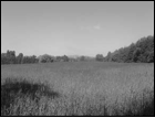
Crooks Family Cemetery
Street Address: Crooks Hollow Road, close to Highway #8
Location: Lot 6, Concession 2, West Flamborough Township
Type of Cemetery: Family (Crooks), Abandoned
Size: Small
History:
The Crooks Family Cemetery was once located on a hill west of the former Crooks House, burial site of Hon. James Crooks and members of his family and friends. The cemetery, in use beginning in 1825, saw its last interment in 1895 with Frances Crooks. By the 1890s the cemetery was in poor repair and over the following decade all the bodies were reinterred in Grove cemetery.
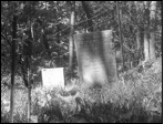
Lyons Family Cemetery
Other Known Names: Lyons Family Cemetery, Harcor Lyons Cemetery
Street Address: Forestview Drive
Location: Lot 20, Concession 1, West Flamborough Township
Type of Cemetery: Family
Responsible Agency: City of Hamilton
Status for Burials: Closed for burials Plot Plan: None
Size: Small, 12 monuments Additional Information: Signage: Signage
Fencing: Chain link and wire Monument Types: Flat and upright Monuments of: Marble
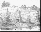
Other Known Names: Lyons Family Cemetery, Harcor Lyons Cemetery Street Address: Forestview Drive Location: Lot 20, Concession 1, West Flamborough Township Type of Cemetery: Family Responsible Agency: City of Hamilton Status for Burials: Closed for burials Plot Plan: None Size: Small, 12 monuments Additional Information: Signage: Signage Fencing: Chain link and wire Monument Types: Flat and upright Monuments of: Marble Date of Opening: February 17, 1817 History: The Crown Patent on this property was to Harcar Lyons, who registered the property in 1798. The site was a family burial ground, first used in 1815 for William Lyons and in 1838 for Harcar Lyons. It is believed that a thick stone wall with a hinged iron gate was erected to surround and define the borders of the burial ground at this time, although this no longer exists. In the mid-1800s, the property was owned by William Passmore who continued to operate the site as a cemetery until 1857. The majority of burials at the site seem to have been relations of property owners, though it is known that in one corner an unrelated farm hand was buried there, having been killed by a bear. In 1965 the cemetery site was damaged by vandals. A decade later, in 1975, Mr. Kalar of Windsor, Ontario, removed the marker of John Kalar and donated it to a Niagara Falls Museum. As a result, the Town of Dundas took ownership of the site and renovated the cemetery property later the same year. The remaining stones were set in a cement pad which included complete monuments, a collection of broken pieces and the marker for Harcar and his wife Mersey which was placed in a central, upright position.
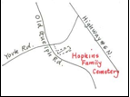
Hopkins Family Cemetery
Other Known Names: Valley Cemetery
Street Address:South side of York Road, between Old Guelph Road and Highway #6 North
Location: Lot 27, Concession 2, West Flamborough Township
Type of Cemetery: Family
Responsible Agency: City of Hamilton
Status for Burials: Closed for burials Plot Plan: None
Size: Small, 25 monuments
Fencing: Hedgerow with open sections
Monument Types: Flat set into a cement pad, and 1 column for the Newman family Monuments of: Marble and granite
Date of Opening: April 6, 1816
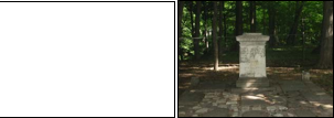
First registered by James Morden in 1798, the property was later registered to Joseph Hopkins in 1803. The burial ground, with a total of 25 stones, was first used in 1816 for Patty Mariah Hopkins and last used in 1905 for Anne Hayes Newman. It is said to be approximately 300 yards long parallel to the Old Guelph Road and can be reached following a dirt track, beside a growth of trees. The majority of stones, both whole and fragments, have been set into a cement pad. The sole remaining independent marker is a family column of the Newman family, which lies at the base of a hill. Access to the site, from either York Road or Old Guelph Road, is not marked.
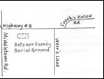
Betzner Family Burial Grounds
Street Address:Bayvista Farm, 253 Hwy #8, West Flamborough Village, South Side of Highway #6
Location:Lot 3, Concession 1 West Flamborough Township
Type of Cemetery: Family (Betzner)
Responsible Agency: Betzner Family
Status for Burials: Open for Burials Plot Plan: None
Size: Small, 4 monuments
Fencing: Wire fencing
Monument Types: Flat and upright Monuments of: Marble
Date of Opening: 1848
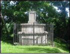
In 1817 Samuel Betzner purchased Lot 3 of Concession 1 from Miller Laurason, and began what is known as Bayvista Farm. On the property, back from the road and on the side of a small knolll, lies the family burial ground, clearly defined by fencing.
Within this plot are five large marble markers, the earliest for Elisabeth Betzner dating from 1848. The burial ground is still in use, although there have been few interments in recent years. In 2004 a clean-up of the cemetery site was undertaken by the family before the ashes of Lloyd Betzner were interred.
The cemetery remains in the hands of the Betzner family.
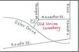
The Old Union Cemetery
Other Known Names: Old Dundas Union Memorial Cemetery
Street Address: Osler Drive
Location: Lot 53, Concession 1 Ancaster Township
Type of Cemetery: Municipal, possibly family Responsible Agency: City of Hamilton
Status for Burials: Closed for burials Plot Plan: None Size: Small, 30 monuments within cenotaph Additional Information:
Fencing: Iron railings, with open sections Monument Types: Flat
Monuments of: Marble
Date of Opening: September 6, 1831
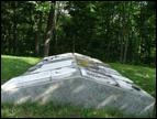
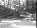
Officially opened in 1831 as a municipal cemetery, it has been suggested that originally the property was used as a family burial ground beginning in 1828. It is claimed that Edward Lesslie was buried there in that year, possibly as part of a Lesslie family burial ground. Its municipal function began with the burial of Elizabeth C. Spencer in 1831. Within twenty years, the cemetery had almost reached capacity and by 1851, it had been replaced as the main burial ground by Grove Cemetery, though Union remained open until 1861.
By 1921, the site had become neglected and Col. J. J. Grafton of Dundas paid for a cleanup. At this time it was discovered that many of the markers had been lost, damaged or broken. Those that remained were gathered together and erected in the form of a large cairn in a fenced corner of the property. Closed for burials, the cemetery property is now maintained by the City of Hamilton.
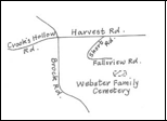
Webster Family Burial Grounds
Street Address: Short Road, Greensville
Location: Lot 12, Concession 1 West Flamborough Township
Type of Cemetery: Family (Webster)
Responsible Agency: Hamilton Region Conservation Authority
Status for Burials: Closed for Burials
Plot Plan: None Size:Small, 6 monuments
Fencing: Iron railings with open section Monument Types:
Flat and upright Monuments of: Marble and granite
Date of Opening: 1863
Joseph Webster Sr., an officer in the British army who came to Dundas from Gloucester, is believed to have purchased this plot of land from Richard Hatt in 1819. About 1822 he died on his journey back to England. His son, Joseph Webster, built the Ashbourne Mills at Webster’s Falls, so he may have been the founder of the small family cemetery. Ellen White was buried on the property in 1865, and Webster’s wife Maria was buried here in 1866.
Given the proximity of the cemetery to the nearby Spencer Creek ravine, stories exist that over the years some of the stones have fallen down the slopes. At present there are six monuments at this site and the Conservation Authority has placed these markers in a cement pad, with only the Joseph and Maria Webster monument still standing upright.
In 1917 area surrounding Webster’s Falls was purchased by the Town of Dundas and developed into a park. This small family cemetery now lies within the boundary of
Webster’s Falls Park which is the responsibility of the Hamilton Conservation Authority.
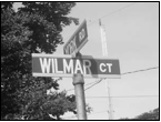
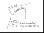
Anne Morden Farm Cemetery
Street Address: York Road at Wilmar Court
Location: Lot 157, Concession 1, Town of Dundas
Type of Cemetery: Family (?), Lost
Date of Opening: 1832 (Possibly)
On property that was registered by the Loyalist Morden Family, 18 bodies were discovered in 1950. The identity of these burials is uncertain. At the time of the discovery, a resident recalled hearing stories of Cholera burials made at the site. It has also been suggested that this was the plot of William Hare’s family, Hare having purchased the property from Anne Morden in 1808. All bodies were reinterred at Grove Cemetery and registered under the name of the Dundas Historical Society.
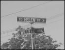
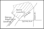
George Rolph Farm Cemetery
Street Address: Around Helen Street
Location: Lot 18, Concession 1 Town of Dundas
Type of Cemetery: Family, Lost/Abandoned
Size: Small
Date of Opening: Possibly 1829
In 1950, while a house basement was being excavated, a number of bodies were found on what is now Helen Street near Wilmar Court and Grove Cemetery. The bodies remain unidentified though it has been suggested that these could belong to either George Rolph and family or the previous owner William Hare and family. These burials were transferred to Grove Cemetery.

"*" indicates required fields