
Watch a quick guide to navigating this site
Watch a quick guide to navigating this site


$5.00
Digital Download Only
Sold By: Ontario Ancestors
MIS 018-Rev_ancaster_twp_part-1
Biggar Family Cemetery
Street Address: South Side of Highway #2 , West of Highway #52
Location: Lot 29, Concession 4, Ancaster Township
Type of Cemetery: Family (Biggar), Abandoned
History:
The Biggar Family Cemetery was located on a hill East of Alberton. It is unclear how many were buried there as no stones or individual records remain. It is believed that the stones were transferred to another cemetery, but where and when is unknown.
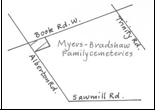
Meyers Family Plot
Street Address: 1910 Book Road West
Location: Lot 29, Concession 4, Ancaster Type of Cemetery: Family
Responsible Agency: City of Hamilton
Status for Burials: Closed for burials Plot Plan: None
Size: Small, 22 monuments
Fencing: Wood
Monument Types: Flat and upright Monuments of: Marble and granite
Date of Opening: 1839 (Myers)
This little corner cemetery contains two separate family cemeteries, one for the Myers family and one for the Bradshaw family.
The Myers plot has existed in this location since at least 1839, though there are illegible markers which may date to an earlier time. The gravestones for the Myers family are currently embedded in a cement pad, at one end of the property.
At the other end of the cemetery is the Bradshaw family plot. Evidence suggests that members of the family were buried at another location, possibly Duff’s Corners, and moved to this spot before 1984, though where it existed prior to this remains unclear. The earliest burial in the Bradshaw section dates to 1822, for Seth Bradsahw, a United Empire Loyalist.
Brandshaw, Myers, O’Connor & Sager are located at this location.
Located on the SE corner of Alberton Road and Book Road, Ancaster Township, Wentworth County, Ontario, Canada moved from Duff’s Corners, Ancaster.
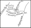
Other Known Names: Hatt Burial Ground, Preserved Cooley Cemetery
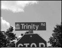
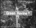
Street Address: 711 Rousseaux, Between Green Ravine and Lime Kiln Road
Location: Lot 49, Concession 2, Ancaster Township
Type of Cemetery: Municipal
Date of Opening: Possibly 1790s
Currently on private land, between Lime Kiln Road and Green Ravine Drive (off Mohawk Road)
Ancaster, Hamilton Municipality, Ontario, Canada
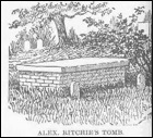
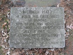
In 1989, the Cooley Cemetery was known to exist, though its exact location was uncertain. The land, registered to Crown Patentee John Smith Jr. and Joseph Smith in 1798, came to be owned by Preserved Cooley in the 1800s, and it was from him that the cemetery received its name. At this site many of the earliest burials in Ancaster took place, possibly as far back as 1785, although certainly by 1801. The cemetery includes the grave of Richard Hatt, founder of Dundas, and his family. Hatt’s tombstone was the last known marker at the site, and was moved to Grove Cemetery in Dundas by James and Bill English circa 1947.
In 1999 a public meeting was held in Ancaster, at which descendants of the pioneers buried at the site suggested that a survey be undertaken to determine the extent of the cemetery, though this was never done. In 2004, while beginning construction on a subdivision, archaeologists discovered grave shafts, with subsequent work identifying approximately 100 burials at the site. Because the developer wishes to move some of the bodies to make way for a subdivision road, while the descendants wish all bodies to be left alone, there is no resolution on the future of the cemetery.
This section of land on his farm given by Preserved Cooley, was Ancaster’s first burying ground. With few records now in existence, it is believed many of the earliest settlers of the area were interred there, from about 1794 through to the early 1820’s, when a formal church was established in the Village.
Re-discovered in 2004 by a local historian on what is now private land and soon slated for a neighbourhood housing development, the abandoned cemetery was the centre of a modern-day land battle until January 2011. Developers have now agreed to re-structure their survey plans to preserve the cemetery intact and the City of Hamilton will restore and maintain the grounds as the final resting place of these early Pioneers.
Current investigations have indicated there may be upwards of 200 interments, and few markers, if any, remain. The earliest known burial is Daniel Cooley (UEL), likely a son of Preserved and Mary Cooley, who d.June 12, 1794.
Word of caution: The land is still in private hands. Public access will continue to be denied until such time as the cemetery grounds are formally transferred to the care of the City of Hamilton.
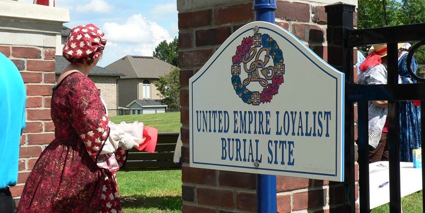
After a long battle to preserve a pioneer cemetery in Ancaster from a developer’s bulldozer, relatives of Richard Hatt and Mary Cooley will be re-dedicating the burial land in October.
“This is an exciting time for our families,” said Richard Hatt, great-great-great grandson of Hatt, “being able to re-dedicate this pioneer cemetery and have proper signage placed so that all will have a change to read and to know some of the history and people that lay buried in this area of Ancaster.”
Richard Hatt (1769-1819) Pioneer, Town Founder
Street Address: On Weir Road, near Powerline Road West
Location: Lot 6, Concession 1, Ancaster Type of Cemetery: Family, Abandoned Responsible Agency: Private
Status for Burials: Closed for burials Plot Plan: None
Size: Small, 2 monuments Additional Information: Signage: No Signage Fencing: Open field Monument Types: Flat Monuments of: Marble
Date of Opening: 1846
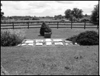
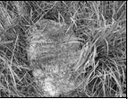
Now virtually abandoned, this small family cemetery is located at the top of a small hill in the middle of a farm field, bordering Weir Road. Under a heavy covering of long grass, two stones were found. The earliest stone, dated 1846, was laid flat, the other partially upright.
The site is overgrown and currently receiving no maintenance. The monuments indicate there are three known burials at the site, although it is suggested that more bodies may be interred at the site.
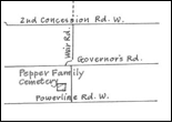
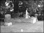
Dyment Cemetery
Street Address: Governor’s Road
Location: Lot 23, Concession 1, Ancaster
Type of Cemetery: Family, Private
Responsible Agency: City of Hamilton
Status for Burials: Open for burials to owners of deeds Plot Plan: None
Size: Small, 17 monuments
Fencing: hedgerow and wire with open section Monument Types: Flat, upright and column Monuments of: Marble and granite
History:
The earliest registered Crown Patentee to this property was Sarah Leget, who registered it on April 4, 1832. One year later, the land was owned by John Dyment, and family who have lived in the area continuously since, except for a brief period from 1880 to 1885. The first burial in the Dyment Cemetery was for Edward Liddycoat in 1873. John Dyment himself passed away in 1878, and stipulated in his will that the North East corner of the farm was to remain a family burial ground, and so it has remained to this day, owned by the family and maintained by the City of Hamilton.
There is only a small collection of monuments spread across the site. In one corner of this small family cemetery, there exists a walled-in area containing just a single upright monument.
"*" indicates required fields